"Magnificent Travels through Nepal & Tibet"
"Magnificent Travels through Nepal & Tibet"
Snowman Trek
Why Book With Us?
- Hassle Free & Best Price Guarantee
- Customer care available 24/7
- Hand-picked Tours & Activities
Get a Question?
Do not hesitage to give us a call. We are an expert team and we are happy to talk to you.
+977 9851157461
Tour Details
Snowman trek is one of the most difficult treks in the world and it travels through the remote Lunana District. The weather, distance, altitude, remoteness makes this a tough journey. If you plan to take this route check your emergency evacuation insurance. If you get into Lunana and snow block the passes, the only way out is by helicopter which will become very expensive. Another obstacle is the bridges in the remote area.
Short Itenary
Day 01: Arrival to Bhutan
Day 02: Drugyel Dzong to Sharna
Day 03: Sharna Zampa to Thang-Thanka
Day 04: Thang_Thanka to Jango-Thang
Day 05: Exploration at Jango-Thang
Day 06: Jango-Thang to Lingshi
Day 07: Lingshi to Chebisa
Day 08: Chebisa to Shomu-Thang
Day 09: Shomuthang to Robluthang
Day 10: Robluthang to Limithang
Day 11: Limithang to Laya
Day 12: Laya to Rodophu
Day 13: Rodophu to Narethang
Day 14: Narethang to Tarina
Day 15: Tarina to Wochu
Day 16: Woche to Lhedi
Day 17: Lhedi to Thanza
Day 18: Thanza to Tshochena
Day 19: Tshochena to Jichu Dramo
Day 20: Jichu Dramo to Thsongsa Thang
Day 21: Thsongsa Thang to Maurothang
Day 22: Muruthang to Sephu
Day 23: Thimphu to paro for depature.
Itinerary
Arrive into the Dragon Kingdom of Bhutan via Druk Air. Escort by our guide and transfer into a hotel. After Lunch we will hike for about 4 hours to Taktsang Monastry which was built around the cave where Guru Rimpoche mediated. The monastery clings on a cliff of rocks at about 914 meters above the valley floor. Then in the evening we will celebrate the night with welcome dinner.
After breakfast, visit the ruins of Drugyel Dzong(2580m) with a short drive down hill to reach Mit-tshe Zam from where we usually start our trek following the river at 2500 meter But now the farm road is up to Gunitshawa, we will drive passing through beautiful small villages, apple orchards and farm houses. The drive takes you through narrow cultivated valley of Gunitshawa (2810m) with a school, crossing the army base camp and reach you at Sharna Zampa. At Gunitshawa you are required to report to the army personals. The trek permit will be checked and endorsed here. All these formalities will be done by your guide while you refresh and hang around with the views. The night will be at Shana (2850m) which is about 17 KM from Drugyel Dzong.
After breakfast, start our trek to reach our destination Thang-Thangkha which is about 22Km. We will cross the old traditional bridge and a village, walking under the shades of trees rhododendron and the conifer forests, breathing in the fresh and thin air of the Himalayas with the birds singing over head to entertain our guests. We have to cross lots of small streams, climbing gently on the hills to reach Shing-Karap, a stone house with a shop at 3110m. The lunch will be served here. After Lunch we will not feel the long and hard walks with lots of up’s and down. We will also come across the white chorten with a log bridge but we will not follow. Then we will follow trail to reach Thang-Thanka where we can see jhomolhari Mountain. And we will halt the night.
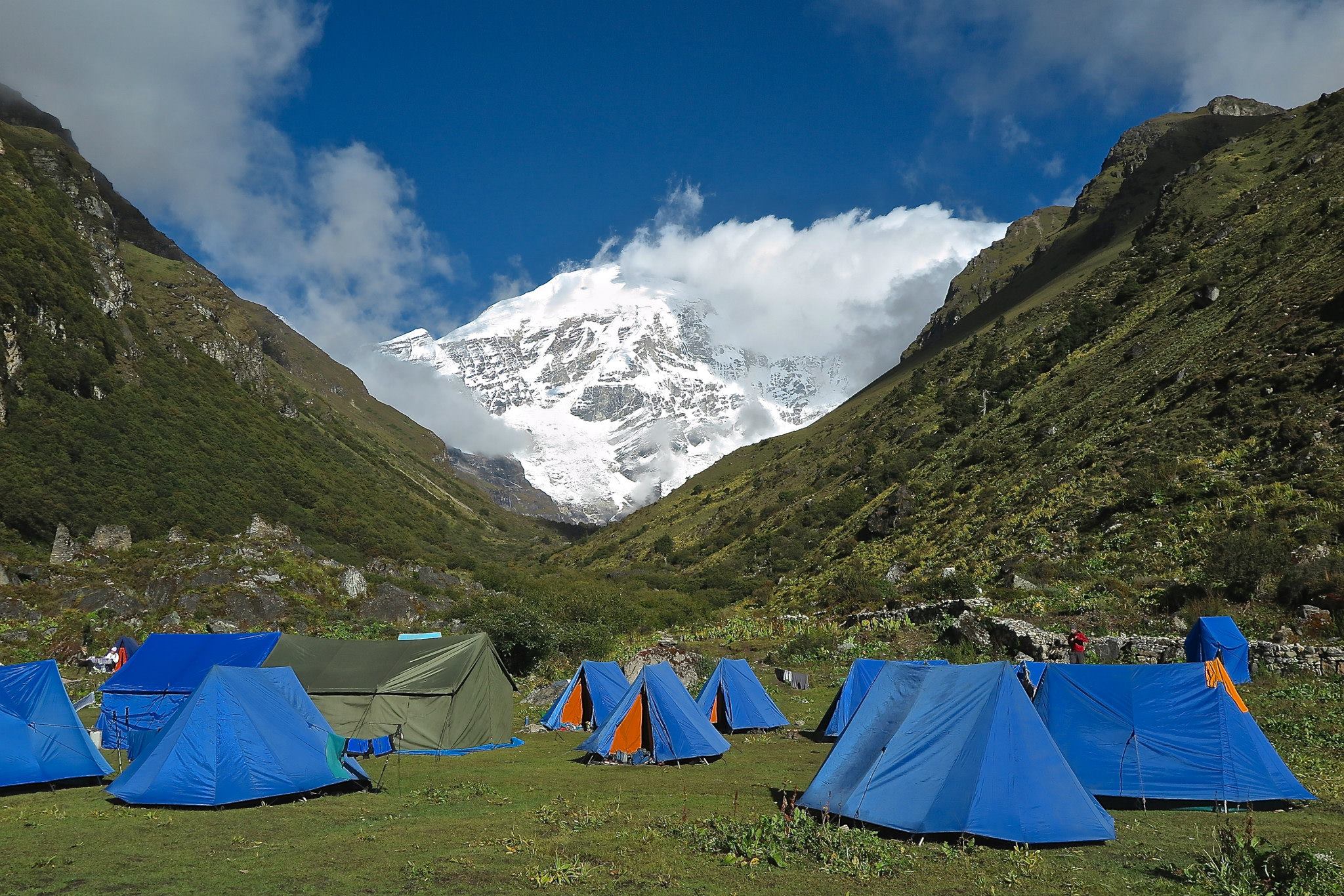
After breakfast our destination is at Jango-Thang ( Base camp of Johomolhari) which is 19 Km from Thang- Thangthangkha and is about 4000 meters. We will cross the army camps of the Indian Militia as well as the Bhutan Militia. The lunch is served in thse areas. On the way you will catch the view of high ridges, feeder streams (clean mountain spring water), water- falls. After crossing a white chorten you will enjoy the beautiful valley of Soi (3940m) where you will find a Basic health Unit, a school and some government representative offices. We will walk further to reach Jango-Thang at the camp.
Halt at Jango-Thang ( Jhomolhari Base Camp) Enjoy the beauty of Jhomolhari Mountain. Mingle up with the localpeople of Soi and talk about the happy mountainous life.(Gross National Happiness). We will also make a day hike, that is 3-4 hour excursion up the ridge to the north of the camp. Ridge is endless, but after an hour of climbing there is a good view of Jichu Drakey, although the upper part of the ridge blocks the view of Jhomolhari unless you continue to climb 4750m. We can also trek up the main valley towards Jichu Drakey or walk in the direction of Jhomolhari which leads to the foot of the mountain. And the other alternative is the fishing expedition to Tshophu, a high altitude lake.
We start our trek towards Lingshi. This journey is the toughest journey. The trek starts from the plains of Jango-Thang, cross the swift flowing streams and the stone houses and then climbs up the swampy path. We will cross the bridge and then walk uphills. As we travel we will find Jichu Drakey and Johmolhari Mountain towering above the Jango-Thang. AT 4470m the trail pass through the big rocks entering the glacial valley at east west. We will find the dwarf Juniper bushes, blue ship on the hillside and the marmots darting into their burrows and the yak herders camp. As we move upward we will meet with the marble route at 4870m. The Nyele la pass is one of the toughest pass which is very windy and breezy with cold air of the Nyele-la pass which is 4800 meters. We will refresh ourselves here climbing on the tip of the marble mountain. We will continue our journey descending the marble slope to a stream on the valley floor at 4450m. The mountain flowers will surround us and it is an excellent place to stop for Lunch. The trail now travels north along the side hill high above the valley floor. We can see the army camps down the river, Jichu Drakey Mountain, Tsherim Kang Mountain and Lingshi Dzong on the top of a ridge in a distance at 4360m. Again trail descends steeply into the large Jaje Chu valley passing through the shades of rhododendron. The camp is at Chha Shi Thang near a large community at 4010m.
After breakfast we will climb up to Visit Lingshi Dzong at 4220m which was built in 1668 by the 3rd Desi Chogyel Menjur Tempa, to commemorate Victory over a Tibetan Invasion. We can view the main village of Lingshi which was clustered by a school, Basic health Units, forests division, post office and shops. Then we will have an excursion to Gang-Yul village at 4140. From Gangyul we will follow the route towards the north to reach Tshokha (15 Km) the base of Jitchu Drakey and Tsherim mountain. We will also concern over the cremation ground.Then we will return to Gangyul. There we will have lunch and visit the Jha Gyoe Dzong. It is very renown because Zhabdrung Ngawang Namgyel meditated when he first came to Bhutan. It is located at 4340 meters away from Gang-Yul valleys on the base of the huge cliff. Then we will follow the inclined route to reach chebisa where we will camp for the night.
The route climbs the ridge behind Chebisa, passing a few houses above the main village, making a long, steep climbs. There are herds of blue sheep living in the rocks above, vultures and the Himalayan griffons flying overheads. You will also come across many medicinal herbs. At about 4410m the trail levels out to Gogu La which leads off the top of the hill. From there the trail descends to a stream at 4170m and climbs over a small ridge through a cedar forests descending to a JholeThang Chhu valley. We will come across some yak herders huts and at 3980m a helipad marked by a big H. After some treks we will come across a good spot to have Lunch.
There you will find yak herders huts downstream. The trail takes you steeply to the north side. At about 4200m we will oversee a yak herders huts and the yak pasture. The path leads through a valley then drop down by the side to Shomuthang.
After breakfast our journey starts to climb up the valley on the right side of the river. The trail climbs to reach Jhari La at 4750m about 2 hours from the camp.In a distance we will see Sinche La , the next obstacle on the route to Laya. The big snow peaks to the north is 6840m Gangchhenta ( Great tiger Mountain). The trail takes us down to the little stream at 4490m, then pass through a rough, rocky route through rhododendron. Soon the vegetations changes to big rhododendron, birches and firs and there are slippery loose rocks on the way. Then we will come across a pleasant Lunch spot at 4050m. Then follow the downstream through bushes to make the way to the main valley, and then to a meadow of the Jholethang Chhu at 3990m. after crossing a stream a yak herders trail leads west up towards Tibet. The camp by the river is called Tsheri Jathang. Here the herds of Takin Migrates in the summer and remain there for about a month. The valley has decleared a special Takin century and the yak herders have agreed not to graze their animals in there. The trail climbs steeply at 4150m and to the tiny lake at Robulthang where we camp in a rockey meadow at 4160m.
This is a long hard day to cross Sinche-la. The last and the highest pass on the trek. Over the hill above the camp is a stone house where a Laya woman lives. She sells trinkets and the local arra (local wine). You can taste some arra and follow the trail which takes you up hillside. After climbing 4390m we will come across a glacial valley. The pass becomes very long along the stream. There will be a icy log bridge at 4470m passing through the foot of the rocks at 4720m. It is the tough climb from here as the altitudes slow your speed. The trail levels in reaching some rocks and prayer flags on Sinche la at 5005m, about five hours from camp.The snow covered peaks of Gangchhenta fill the horizon in the north. The descend is on the rough, rocky trails that leads to the glacial village. Then we will reach Kango Chhu, astream below a terminal moraine that forms the end of another valley to the west. Then we will continue to reach Limithang following the valley north. Again we have to cross Kango Chhu at 4260m and travel through rhododendron to reach the plateau above Zamdo Nangi Chhu. It is then a short walk to Limithang where we will halt the night. At 4140m.
Strenuous hike leads to the river at the left and enter deep forest crossing many muddy streams. You will come across a herders stone hut from where the vegetation changes. Crossing a large stream from the north we have to descend steep, rocky side of the valley at 3800m crossing the wooden cantilever bridge. After a stiff climb it will be a long walk in the woods, descend to cross the waterfall followed by many up’s and downs. When we reach a single house, there will be a junction for the upper Laya and lower Laya. We will like the beautiful clustered houses surrounded by the wheat fields of Laya. The community nhas school, Basic health units, and some government representative offices and some shops. Laya is a unique village of about 800 people with their own language, customs and distinct dress. The women keep their hair long and wear peculiar conical bamboo hats with a bamboo spike at the top. They wear a lot of silver jewellery on their backs, on many women this display includes an array of teaspoons.
The trek leads gradually downhill to the Lunana trail junction, then makes a gradual climb to the camp through a forest of conifers, maple and rhododendron. The rough trail continues to climb gradually up the Rhodo-chhu valley. At the top of th large rock slide there is an excellent view of the broad glacial valley and a massive glacier on Tshenda- Kang( 7100m) towering overhead. If we have a time we can have short hikes for about 2Km which will give a good view of the valley and the Mountains around.
The trial follows the wooden bridge and follow the river for about 20 minutes through rhododendron shrubs before turning right for the hill. Climb to a valley at 4600m then to Tshomo La (4900m) which has a good view towards the Tibetan boarder and Jhomolhari. The trail takes us through the flat, barren plateau at about 500m with yak herders trail in every directions. Then we will trek towards Narethang (4900m) below 6395m peak of Gangla Karchung.It is a long hike, first crossing the Tsimo La pass at 4950m (16,200 ft). Descending to Narethang we pass some dwarf rhododendron and hike in the shadow of Gangla Karchung peak (6395m). We camp at 4900m (16,000 ft).
Rest Day
The walk leads down through conifer forests down the Tang chhu with some impressive waterfall cascading on both side of the valley past several landslides. Following the upper reaches of the Pho Chhu River. The trail then climbs over a ridge and drops to the village of Woche at 3940m (13,000 ft) where we spend the night. The trek has now entered the Lunana region. Looking up the valley we can see the following route to Lhedi.
The trail climbs the Woche valley, crossing the stream and climbing over a mountain before descending to a wooden bridge to cross the Woche chhu then takes you past a clear Lake to Keche La (4650m). From there we can see the source of the Woche Chhu, Jejekangphu Gang’s triple peak. Then descends to a po-chhu valley, the heart of the Lunana. In the small valley of Thaga (4050m) the farmers grow Buckwheat, wheat, potatoes, radishes and turnips. The route drops towards the pho-chhu and turns north east towards Lhedi which can be seen from a distance above the river. The lake of Thanza got burst in 1994 causing a big disaster in Punakha. Passing a few scattered settlements and crossing below a water fall on a wooden bridge, the trail descends to the banks of Pochhu along the river bed until we reach Lhedi at 3700m. Lhedi is the district head quarter with school, basic health Unit and wireless stations but there are no shops. Strong winds blows in the afternoon.
The trail follows the north bank of Pho Chhu Passing small farms. There will be an excellent view of Table Mountain(7100m) to the north and Tangse Gang across the river. Temporary path takes you through the massive boulders in the river beds, crossing small bridges several times. The Lunch will be served at Chozo village at 4090m. The village has a small Dzong which is still in use. Then the trail will take us directly to Thanza at (4100m) a few hours up the valley where we spend the night. We will explore the villages and the glacial lakes up the valley. The closest lake is Raphstreng Tsho which is 100m deep and many lakes in the area that could burst any time.
The route climbs from Toencha to a large boulder on the hill south of the village. From the boulder there are excellent view of Thanza, Toencha, Chozo and the surroundings Mountains. The path takes you to the east side valley and then through yak meadow with some yak herder’s huts. The Lunch will be served at Dhanji with the beautiful sightseeing around. After Lunch the trail junctions from Dhanji to GangKhar puensum base camp and to Bumthang. The route leads to a rockey side valley. It is a long climb across Jaze La at 5150m which gives a spectacular Mountain voews all around. The the trail decends between snow covered peaks and passes a string of small lakes. The camp site is at the lake of Tshochena at 4900m (15,740 ft). Keep your eyes open for blue sheep during the hike.
The trail follows the shore of the blue –green lake before climbing to a ridge at 5100m. AT the top we will be surrounded by 360 degree panorama of snowy peaks, while far below pochu descends towards punakha. The road and the microwave tower of Dochula will be visible. We have to make several up’s and downs over small rounded hills descending past a glacial lake before we climb to Loju La pass at 5140m. Then we cross a small saddle at 5100m into a wide glacial valley which takes us to the camp site at Jichu Dramo at 5050m.
The trail climbs to Rinchen Zoe La at 5320m which divides pochhu and Mangde Chhu drainages. Rinchen Zoe peak ( 5650m) towers above the pass to the west and major Himalayan mountain stretches along the northern horizon and to the west Gangkhar punsum is seen while Thampe chhu valley stretches below to the south. From the pass the trail descends to a broad marshy valley at the left narrows as you move. The trail descends steeply down to reach Thampe chhu. We will follow the west bank of the river. The vegetation gradually become thicker with rhododendron, junipers shrubs and eventually to trees of both speces and then we will reach Chhukarpo but we will continue further 1 hour to reach Thsongsa Thang at 4400m. it has a better site.
It is a long mostly downhill walk along the river until we reach the yakpasture at Gala pang chhu at 4010m. we can spot Takins on thehill across the river. From here the trek begins to slope steeply through juniper and silver fir forests towards Tampe Tsho following the stream to the beautiful lake, set in a bowl and surrounded by steep Mountain walls. The lunch will be served and climb steeply to Thampe La at 4600m. The route descends to Om Tsho, sacred because pema Lingpa discovered many treasure ( terma) here. The path then skirts the north western shore of the lake before crossing its outlet, marked by a strings of prayer flags and drop steeply pass waterfall to a smaller lake, about 100m lower. Then the route descends to Nikka Chhu which is steep. The route follows the left bank of Nikka Chhu. After 2 kmwe will be at the confluence of major tributary coming from the east. We will cross the wooden bridge and pass through mixed forests to Mourothang(3610m) where we will spend the night.
A trail continues down the west side of Nikka Chhu for about 30 minutes before crossing to the east bank in the deciduous forests. It will emerge to a large grassy area overlooking the road and the village of sephu. Look for a larger trails here as it has many trails about 20-30m above the river and we will meet with the large suspension bridge over a Nikka Chhu river and then we will meet with road at 2600m. There are several shops and restaurants near the bridge. After Lunch, we will be transported to a hotel in Thimphu through Dochula pass where we will visit the Druk Wangyel Lhakhang with story crafted on the walls and enjoy the scene of 108 chortens with the big story behind.
After breakfast we will drive to Paro for the departure.
Trip Format
- Applicable Airport Taxes and Visa Fees.
- Accommodation with all meals in 4 star hotels and accommodation on trek.
- Transportation during the trek.( horse and the Yaks)
- Return Airport transfers All transfers and sightseeing.
- Professional guide, driver chauffeur, cooks, waiters.
- Mineral water throughout the Trip.
- Royalty and taxes No hidden cost.
- Cultural dance in Thimphu (If needed) Use of Conference hall for Yoga or meditation.( If needed)
- Tea and Coffee.
- Travel Insurance charges and other emergencies fee.
- Cost of foreign exchange for personal expenses; Expenses of personal nature, personal trekking aids, mini bar in the room, laundry, telephone bills, tips, gratuities etc.
- First Aids Kids (personal) Surcharges applicable during Conventions, Special Events and Trade fairs.
| Start date | End date | Price | Status | Book |
|---|---|---|---|---|
|
7900
|
guaranteed | Book Now |
Map
Why Book With Us?
- Hassle Free & Best Price Guarantee
- Customer care available 24/7
- Hand-picked Tours & Activities
Get a Question?
Do not hesitage to give us a call. We are an expert team and we are happy to talk to you.
+977 9851157461

